Table of Contents
Introduction to Plane Table Surveying
Plane table surveying is a graphical method of surveying, and we can plot maps directly by drawing on site. This makes this method popular. Now it is used for small or medium work where higher accuracy isn’t needed. Plane table surveying gives approximate data.
The principle of plane table surveying is parallelism. It simply means that we are using the Alidade, which is used to draw lines on the drawing sheet, parallel to the sightline.
Pros and Cons of Plane Table Surveying
Pros of Plane Table Surveying
- Drawing could be prepared while surveying. This will save time for plotting field data on the drawing sheet.
- There is no need to maintain the field book.
- This is less costly than theodolite survey.
- There is no chance of omitting any measurements since the map is prepared on the ground.
- No highly skilled labor is needed as all the tasks are comparatively easy.
Cons of Plane Tabling
- In the rainy season, plane tabling is not possible. It is inconvenient to carry Plane Table and all other instruments in field, particularly in a muddy area.
- Plane Table Surveying could be done only in day time, at night it is not possible to carry out surveying.
- Surveyor needs to carry a lot of instruments along with him.
- It is an approximate method and hence couldn’t be used for a big project.
- As in the case of Plane Tabling, no field data is recorded, and it would be difficult to reproduce the map.
Instruments Used in Plane Table Surveying
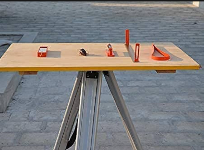
Plane Table
It consists of a drawing board attached to a tripod stand. There are many types of plane tables available in the market.
- Simple Plane Table
- Johnson Plane Table
- Coast Survey Table
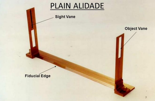
Alidade
It is used to sight the object and draw the lines on the drawing sheet. There are two different types of alidade.
- Plain Alidade:
- A simple sighting device consisting of a straight edge with vertical sight vanes at both ends.
- Used primarily for drawing straight lines and sighting nearby objects with moderate accuracy.
- Lightweight and easy to use, making it ideal for basic fieldwork and educational purposes.
- Telescopic Alidade
- Equipped with a small telescope mounted on a straight edge for precise sighting and angular measurement.
- Offers higher accuracy and longer range visibility, especially useful in topographic and engineering surveys.
- Includes features like bubble levels and stadia hairs for elevation and distance estimation.
Spirit Level
It is used to level the plane table. Spirit Level is also known as Tube Level.
The sensitivity of the spirit level depends on many things.
- Viscosity – The lower the viscosity of the fluid used in the spirit level, the higher the accuracy, and vice versa.
- Radius of Curvature: The sensitivity is directly related to the radius of curvature of the vial. A larger radius means higher sensitivity, as the bubble moves more easily with smaller changes in angle
Trough Compass
It contains a magnetic needle casing in a wooden or non-metallic box. It is used to locate the north-south direction.
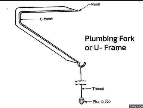
U Fork or Plumbing Fork
U Fork is used for centering of the Plane Table. The U Fork is attached with a plumb bob at one end, and the other end is to be kept at the center of the drawing sheet for the centering of the Plane Table.
Methods of Plane Tabling
There are four well-known and conventional methods, though still used to do surveying with a plane table.
- Radiation
- Intersection
- Traversing
- Resection
Each of the above is explained below.
Radiation
This method is most suitable when all the distances to be measured are small and readings should only be taken from one location. In radiation method, the plane table is fixed at one station, and lines toward observed points are drawn with the help of alidade.
Intersection Method
This method is suitable for locating inaccessible points from the two well-known positions on the ground. This method is useful for accurately locating points that are difficult to measure directly, such as the tops of hills or buildings.
Traversing Method
This method is used to connect the station of an open or closed traverse. In this method, the plane table is moved sequentially along a series of stations.
Resection Method
Resection is the general term used for the process of determining the location of the station occupied by the instrument. There are 4 ways to employ the resection method
- Compass Method
- Back Ray Method
- Two-Point Problem
- Three-Point Problem
Resection by Compass
This method involves orienting the plane table using a magnetic compass. The surveyor aligns the table to magnetic north and then sights known points to draw resectors. The intersection of these lines determines the location of the instrument station. It’s a quick method but prone to magnetic errors and less accurate in areas with magnetic disturbances. It’s mainly used when other orientation methods are not feasible.
Resection by Back Sighting
Here, the plane table is oriented by sighting back to a previously plotted station. The surveyor sets up the table at a new point and aligns it by sighting a known location already plotted on the map. Then, resectors are drawn to other known points. The intersection of these resectors fixes the new station. This method is more accurate than compass resection and is commonly used in progressive surveys.
Two-Point Problem
In this method, the surveyor uses two known points to orient the table and determine the instrument station. Initially, an approximate orientation is made, and resectors are drawn to the two known points. Then, adjustments are made using trial and error or graphical methods (like Lehmann’s method) until the resectors intersect correctly. This method requires careful handling and is less accurate than the three-point method, but useful when only two points are visible.
Three-Point Problem
This is the most reliable and accurate resection method. The surveyor sights three known points whose positions are already plotted. After orienting the table approximately, resectors are drawn to all three points. The correct orientation is achieved when all three resectors intersect at a single point, which fixes the location of the instrument station. Methods like Bessel’s or Lehmann’s graphical solution are used to refine the orientation.
Objectives of Plane Table Surveying
- To prepare a detailed and accurate map while taking observations.
- To determine the distances, angles, and directions of various points on the ground.
- Establishing control points and reference marks on the ground for future surveys.
- Gathering data for designing smaller infrastructure projects.
Read Also-
Basic Principles of Surveying | Fundamental Civil Engineering
Highway Alignment and Its Requirements
Types of Surveying (A Comprehensive Classification)
Types of Chains Used in Surveying
International Building Code 2018 Version
International Building Code 2021 Version
FAQs
The straight working edge used to draw lines in the alidade is called the fiducial edge of the alidade.
Plane Table Surveying works on the principle of Parallelism.
There are four methods to solve 3 point problem namely trial and error method, tracing paper method, Bessel’s graphical method, and analytical methods.
2 point problem is used for orienting the plane table when two prominent and identifiable points are available, both in the field and on the map.